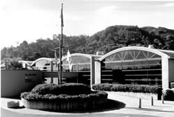
To understand how the water flows in the Bay, the U.S. Army Corps of Engineers constructed the San Francisco Bay Model in 1957. We were able to study this large system due to the fact that the model of the Bay is much smaller than the actual San Francisco Bay and Delta, approximately the size of two football fields. The time scale,running 100 times faster than nature, permits us to observe a long sequence of events in a short time period.
The hydraulic model, the largest of its kind, was used as a scientific research tool from 1958-2000 to evaluate circulation and flow characteristics of the water within the estuary system associated with the geometry or shape of the Bay and related waterways. Assessments could be made regarding the impact of man's activities such as dredging navigation channels, filling portions of the Bay, diverting water, introducing wastes and oil spills. Although the model does not look exactly like the bay or delta, its action is similar. Think of the model as a simulator of bay and river conditions, rather than as a model of familiar landmarks.
The model used to reproduce (to the proper scale) the rise and fall of tide, flow, and currents of water, mixing of salt and fresh water, and indicates trends in sediment movement.
The limits of the model encompass the Pacific Ocean extending 17 miles beyond the Golden Gate, San Francisco Bay, San Pablo Bay, Suisun Bay and all of the Sacramento-San Joaquin Delta to Verona, 17 miles north of Sacramento on the north, and to Vernalis, 32 miles south of Stockton on the San Joaquin River on the south.
The model is approximately 320 feet long in the north-south direction and about 400 feet long in the east-west direction. It is constructed out of 286 five ton concrete slabs joined together like a jigsaw puzzle. Features that affect the water flow of the San Francisco Bay and Sacramento-San Joaquin Delta are reproduced, including ship channels, rivers, creeks, sloughs, the canals in the Delta, fills, major wharfs, piers, slips, dikes, bridges, and breakwaters.
The research department of the Bay Model was closed in 2000, but the model continues to operate as a public education center. As the mission of the Bay Model moves away from scientific research and more toward interpretation and education, the associated Visitor Center and interpretive staff continues to provide public programs focusing on water policy and environmental issues relevant to the Bay and Delta regions.