NAPA RIVER
OPERATIONS AND MAINTENANCE
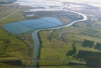
PROJECT LOCATION AND DESCRIPTION
The Napa River Channel is a shallow draft channel approximately 16 miles long, that is mainly used for light commercial and recreational navigation. The Channel extends from the City of Vallejo, which is located on San Pablo Bay, northward to the City of Napa. The Operations and Maintenance (O&M) schedule provides for a six-year cycle of maintenance dredging for the Channel to a depth of 15 feet Mean Lower Low Water (MLLW) from the Mare Island Strait Causeway to Asylum Slough (downstream portion) and 10 feet MLLW to the head of navigation at the Third Street Bridge in the City of Napa (upstream portion). The channel was last dredged in FY22 approximately 35,000 cyds of material was removed during the operation.
|
TOTAL FUNDING
|
|
|
TOTAL COST
|
N/A
|
|
FEDERAL COST
|
N/A
|
|
NON-FEDERAL COST
|
N/A
|
|
|
|
|
FISCAL YEAR 2023 ALLOCATION
|
$0
|
|
FY 2024 ALLOCATION
|
$0
|
|
COST TO COMPLETE
|
N/A
|
FY23 ACCOMPISHMENTS
- Complete Geospatial Land Data Migration into the Corps Map system.
FY24 ACCOMPLISHMENTS
- Annual condition survey conducted on the channel.
ISSUES AND OTHER INFORMATION
- The Napa County Flood Control and Water Conservation District is the NFS.
- The NFS has been actively pursuing additional Congressional funding.
- The project is on a 6-year cycle. However, in FY17, major winter storms caused a large amount of runoff silt to fill the channel with depths in some locations of -2 ft or less.
- The channel was dredged in FY16 and approximately 70,000 cubic yards of material was removed.
- Two of three reaches of the channel was dredged in FY22 and approximately 35,000 cubic yards of material was removed. The third reach was not dredged due to capacity issues at the upland disposal site. Approximately 8,800 cubic yards of material was not dredged at Reach 3.
- The project delivery team continues to coordinate with the NFS on closeout of the FY22 dredging episode. The NFS is also implementing a large flood-reduction project with the Sacramento District, USACE. Maintenance of the navigation channel in the Napa River will benefit the Napa River flood reduction project.
CONGRESSIONAL INTEREST
- 4th District, Rep. Mike Thompson
- 8th District, Rep. John Garamendi
POINT OF CONTACT
- Deputy for Project Management, Thomas R. Williams, 415-503-6560
Updated on 29 February 2024
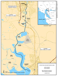
Click Map to Zoom In