PETALUMA RIVER
OPERATIONS AND MAINTENANCE
PROJECT LOCATION AND Description
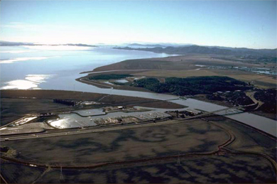
The Petaluma River is located on San Pablo Bay in Sonoma and Marin Counties, California. Operations and Maintenance (O&M) provides for dredging of a channel 200 feet wide to a depth of -8 feet Mean Lower Low Water (MLLW) across the flats in San Pablo Bay to the mouth of the river (Across-the-Flats Channel), 100 feet wide and -8 feet MLLW thereafter to Western Avenue in Petaluma (River Channel), and a turning basin 300 to 400 feet wide to -8 feet MLLW. The Non-Federal Sponsor (NFS), City of Petaluma, is responsible for providing a suitable upland placement site.
|
TOTAL FUNDING:
|
|
|
|
|
|
TOTAL COST:
|
N/A
|
|
FEDERAL COST:
|
N/A
|
|
NON-FEDERAL COST:
|
N/A
|
|
|
|
|
FISCAL YEAR 2025 ALLOCATION
|
$1,000,000
|
|
FY 2026 BUDGET:
|
$ 996,000
|
|
COST TO COMPLETE:
|
N/A
|
FY 26 ACCOMPLISHMENTS
- Updates are in progress. Check back soon for more information.
FY 25 ACCOMPLISHMENTS
- FY25 Petaluma River maintenance dredging completed.
- BUDDI updated to open up beneficial reuse placement site possibilities. City of Petaluma was able to cost share funds alongside the SCC.
FY 24 ACCOMPLISHMENTS
- BUDDI completed to cost share project with State Coastal Conservancy and bring material to beneficial reuse.
ISSUES AND OTHER INFORMATION
- The City of Petaluma is the NFS.
- The Across-the-Flats Channel maintenance dredging cycle is every three years. The last time the Across-the-Flats Channel was dredged was in FY 2020
- The River Channel maintenance dredging cycle is every four years. The last time the River Channel was dredged was in FY 2020.
CONGRESSIONAL INTEREST
- 2nd District, Rep. Jared Huffman
POINT OF CONTACT
- Deputy for Project Management, Thomas R. Williams, 415-503-6560
Updated on 20 February 2026
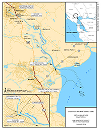
Click Map to Zoom In