Contact

Bay Model Visitor Center

2100 Bridgeway

Sausalito, CA 94965

Phone: 415-332-3871

Fax: 415-289-3004

Wetlands

Collapse All Expand All
 What is a Wetland?


The U.S. Army Corps of Engineers defines wetlands as areas that are inundated or saturated by surface water or groundwater at a frequency and duration sufficient to support vegetation typically adapted for life in saturated soil conditions. Wetlands generally include swamps, marshes, bogs, and similar areas. The U.S. Fish and Wildlife Service defines wetlands as transitions between terrestrial and aquatic systems where the water table is usually at or near the surface or the land is covered by shallow water (Cowardin, 1979).

Wetland are areas that are covered by water or have waterlogged soils for long periods during the growing season. Plants growing in wetlands are capable of living in saturated soil conditions for at least part of the growing season. Wetlands such as swamps and marshes are often obvious, but some wetlands are not easily recognized, often because they are dry during part of the year or “they just don’t look very wet” from the roadside. Some of these wetland types include: swamps; freshwater, brackish water, and saltwater marshes; vernal pools, periodically inundated saltflats; intertidal mudflats; wet meadows; wet pastures; springs and seeps; portions of lakes, ponds, rivers and streams.

Functions of Wetlands

Much of the planet's life depends on the existence of wetlands. They are vital to the survival of many fish and other aquatic life forms, birds and plants. They filter and clean water, prevent soil erosion and provide flood control among numerous other benefits.


 Wetland Characteristics


The Corps uses three characteristics of wetlands when making wetland determinations – vegetation, soil, and hydrology. Unless an area has been altered or is a rare natural situation, wetland indicators of all three characteristics must be present during some portion of the growing season for an area to be a wetland. Each characteristic is discussed below. However there are some general situations in which an area has a strong probability of being a wetland. If any of the following situations occur, you should ask the local Corps office to determine whether the area is a wetland:

  • Area occurs in a floodplain or otherwise has low spots in which water stands at or above the soil surface during the growing season. Caution: Most wetlands lack both standing water and waterlogged soils during at least part of the growing season.
  • Area has plant communities that commonly occur in areas having standing water for part of the growing season (eg. Cypress-gum swamps, cordgrass marshes, cattail marshes, bulrush and tule marshes, and sphagnum bogs).
  • Area has soils that are called peats or mucks.
  • Area is periodically flooded by tides, even if only by strong, wind-driven, or spring tides.

Many wetlands can be readily identifies by the general situation stated above. For the boundary of these areas and numerous other wetlands, however, it is unclear whether these situations occur.

In Such cases, it is necessary to carefully examine the area for wetland indicators of the three major characteristics of wetlands – vegetation, soil, and hydrology.


 Hydrology Clues


Wetland hydrology refers to the presence of water at or above the soil surface for a sufficient period of the year to significantly influence the plant types and soils that occur in the area. Although the most reliable evidence of wetland hydrology may be provided by gaging station or groundwater well data, such information is limited for most areas and, when available, requires analysis by trained individuals.

Thus most hydrologic indicators are those that can be observed during field inspection. Most do not reveal either the frequency, timing, or duration of flooding or the soil saturation. However, the following indicators provide some evidence of the periodic presence of flooding or soil saturation:

  • Standing or flowing water is observed on the area during the growing season.
  • Soil is waterlogged during the growing season.
  • Water marks are present on trees or other erect objects. Such marks indicate that water periodically covers the area to the depth shown on the objects.
  • Drift lines, which are small piles of debris oriented in the direction of water movement through an area, are present.
  • These often occur along contours and represent the approximate extent of flooding in n area.
  • Debris is lodged in trees or piled against other objects by water.
  • Thin layers of sediments are deposited on leaves or other objects. Sometimes these become consolidated with small plant parts to form discernible crests on the soil surface.

 Soil Clues


There are approximately 2,000 named soils in the United States that may occur in wetlands. Such soils, called hydric soils, have characteristics that indicate they were developed in conditions where soil oxygen is limited by the presence of saturated soil for long periods during the growing season. If the soil in your area is listedas hydric by the US Soil Conservation Service (SCS) [information avalible from the local county SCS], the area might be a wetland. If the name of the soil in your area is not known, an examination of the soil can determine the presence of any hydric soil indicators, including:

  • Soil consists predominantly of decomposed plant material (peats or mucks).
  • Soil has a thick layer of decomposing plant material on the surface.
  • Soil has a bluish gray or gray color below the surface, or the major color of the soil at this depth is dark (brownish black or black) and dull.
  • Soil has the odor of rotten eggs.
  • Soil is sandy and has a layer of decomposing plant material at the soil surface.
  • Soil is sandy and has dark stains or dark streaks of organic material in the upperd layer below the soil surface. These streaks are decomposed plant material attached to the soil particles. When the soil from these streaks is rubbed between the fingers, a dark stain is left on the fingers.


 Vegetation Clues


Nearly 5,000 plant types in the United States may occur in wetlands. These plants, known as hydrophytic vegetation, are listed in regional publications of the US Fish and Wildlife Technical Information Services (NTIS). However, you can usually determine if wetland vegetation is present by knowing a relatively few plant types that commonly occur in your area. For example, cattails, bulrushes, cordgrass, sphagnum moss, bald cypress, willows, mangroves, sedges, rushes, arrowheads, and water plantains usually occur in wetlands. Other indicators of plant growing in wetlands include trees having shallow root systems, swollen trunks (eg. Bald cypress, tupelo gum) or roots found growing from the plant stem or trunk above the soil surface. Several Corps offices have published pictorial guides representative wetland plant types. If you can not determine whether a plant types in your are those that commonly occur in wetlands, ask your local Corps District Office or a local botanist for assistance.


 What Can We Do?

Water Quality Protection and Improvement
The U.S. Army Corps of Engineers are involved in improving the wetlands becauseWater passing through a wetland carries with it organisms, sediments, nutrients and pollutants.The vegetation and soil in the wetland form a kind of sieve, trapping those materials and filtering the water.

Flood Control and Groundwater Recharge
The retention and slow release of flows in freshwater wetlands can lessen the effects of flood peaks and provide groundwater recharge.

Erosion Control
Where a wetland borders a large or deep water body, vegetation protects against erosion by stabilizing banks and damping wave energy.

Fish and Wildlife
The combination of vegetation and open water in wetlands provides food, rearing areas and cover for waterfowl and shorebirds, as well as spawning habitat and food for freshwater and marine fishes. Many species of birds and fish are absolutely dependent on wetlands.

Biological Diversity
Because aquatic and terrestrial habitats overlap in wetlands, they serve wildlife from both realms, as well as plants and animals that have adapted specifically to life within the wetlands The multitude of wetland organisms includes 41 of the state's rare and endangered species.

Recreation

The diversity of wildlife and aesthetic qualities found in many wetlands attract large numbers of outdoor enthusiasts, including hunters, anglers, boaters, birdwatchers and photographers.

Even as appreciation for the benefits provided by wetlands has grown over the last couple of decades, wetlands continue to be filled, drained, and dredged. California today has only 10 percent of the wetlands that existed before settlement by Europeans. The Central Valley once had vast wetlands extending over some 4 million acres; these have diminished to a mere 300,000 acres. Only 5 percent of the state's coastal wetlands remain intact. Government efforts in response to these losses have come in the form of legal restrictions on uses of wetlands, as well as protection through acquisition, restoration and management. The lands with the greatest potential for wetland restoration and management are mostly in private ownership playing a significant role in stewardship.


 Salt Marshes


The most extensive salt marshes of the West Coastal States occur in the San Francisco Bay. However, historic reclamation of these tidelands in California has reduced these vital areas by more than 80 percent in the Bay. Past, unrestricted destruction of salt marshes has substantially increased its contributive importance to today’s Bay ecosystem, and has caused the passage of numerous laws and regulations to protect what little we have left. The public now recognizes the salt marsh’s numerous values; ranging from flood, erosion, pollution and sediment control to providing essential habitat for diverse types of wildlife and forming the basis of a complex food web.

The eight species of salt marsh plants are typical of what can be found in the salt marshes of the San Francisco Bay. They bloom or “go to seed” primarily during the summer when the grasslands around the Bay turn brown, adding a stark color contrast between the Bay’s lowlands and uplands.


 Salt Marsh Plants

Cordgrass
Spartina foliousa
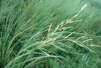

This plant forms the lower edge of the salt marsh in San Francisco Bay, near mean sea level, and appears to be the only plant (other than marine algae) that can successfully tolerate alternate exposure and flooding of saltwater. Cordgrass grows to four or more feet high. During high tide when the cordgrass is mostly underwater, oxygen is passed down to the roots from the leaves via hallow tubes in the stem and rhizomes, enabling the roots to survive. It tolerates the high salt content of the Bay by exerting unneeded salt through salt glands in the leaves.

Cordgrass is known for its high productivity whereby it produces tremendous amounts of organic material every year called detritus. Detritus forms the basis of the food web that many animals are dependent upon, including: clams, oysters, shrimps, crabs, fish, waterbirds, and even man.

Pickleweed
Salicornia
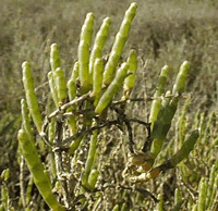
 

One of the more common and unusual looking plants of the salt marsh is the pickleweed or grasswort. It has no leaves and thus photosynthesis occurs in the jade grass stems. (Some feet that the stems are, in fact, the leaves, however greatly modified). Unlike cordgrass and saltgrass, pickleweed does not excrete the excess accumulated salt through special glands. Instead, it concentrates the salt in its joints, succulent stems and by autumn, the ends of the stems turn pink to iridescent red, dry up and eventually break off; thereby ridding itself of the excess salt. The pickleweed has tiny yellow flowers that appear on the stem in summer with male and female flowers on separate plants. In some areas of San Francisco Bay the pickleweed provides habitat for the salt marsh harvest mouse and clapper rail, two endangered species.

Salt Marsh Dooder
Cuscuta salina
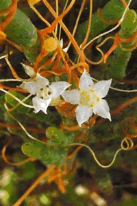
During the summer, mats of tangled orange threads on pickleweeds, gum plants and other high marsh plants can be readily seen. These orange threads are actually a parasitic plant called the marsh dodder that lacks chlorophyll. The germinated seeds initially develop into free-living (non-parasitic) young plants, green with chlorophyll. Once the youngdodder reaches a host plant, such as a pickleweed, it sends roots into the host and the original roots and stems die. The dodder then loses most of its green color and develops orange threads and tiny white flowers, securing its nutrients from its host.

Saltgrass
Distichlis spicata
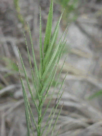
Saltgrass is quite common and often occurs in dense mats, 8-12” tall, in the high marsh area. It has many distinct narrow, pointed blades that alternate up the stem. The stiff blades typically are overladen with salt crystals, which are excreted by special salt glands on the blades. Often, it is found together with pickleweed and other salt marsh plants, andlike the pickleweed, male and female flowers occur on different plants (diocious) during late spring to summer.

Alkali bulrush
Scirpus robustus

The alkali bulrush is typically found in brackish marshes and its seeds have high food value for waterfowl. Its stem, like many sedges, is triangular and has alternate slender leaves growing on it. The florets are red-brown and clustered at the top of the stem with smaller leaves (typically three to four) coming out from the base of the florets. It blooms from late spring through the summer, and can grow five feet tall.

Brass button
Cotula coronopifolia
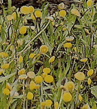

This low-lying herb is particularly abundant in brakckish marshes and is an important food plant for waterflow. Its common name, bass button, is attributed to its brassy yellow flower. The flowers bloom during the summer into winter and resemble daisy centers without rays. Its succulent stem have alternate leaves.

Jaumea
Jaumea carnosa
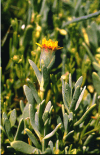
Superficially, Jaumea looks like pickleweed because it is low-lying and has succulent parts. Unlike pickleweed, Jaumea has succulent leaves (the pickleweed is leafless but has succulent stems). It is not as common as pickleweed in the Bay marshes.

Sea lavender
Limonium californicum
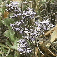


used with permission of www.laspilitas.com

Relatively uncommon in the San Francisco Bay, the sea lavender (also called the marsh rosemary) is a distinctive high marsh plant. When in bloom during summer through early winter, it has delicate lavender or violet, five-petaled flower borne on lacy branches. The winter, it has delicate lavender or violet, five-petaled flower borne on lacy branches. The stems are leafless but it does have broad, leathery green leaves that grow at the base of the plant. The lower portion of the stem is reddish. Sea lavender grow to about 24 inches high. Since it occurs in the high marsh area, it is often found associated with saltgrass.


 Resource Links

List of San Francisco District Projects
http://www.spn.usace.army.mil/projects/

An Introduction to Estuaries (National Estuarine Research)
http://www.baruch.sc.edu/

The Young Scientist's Introduction to Wetlands

http://www.wes.army.mil/el/wetlands/

National Estuarine (NOAA)
http://cdmo.baruch.sc.edu/

Wetland Web Sites (SWS)
http://www.sws.org/wetlandweblinks.html

Wetland/Environmental ( Indiana University)

http://ezinfo.ucs.indiana.edu/~cgolini/envlink.html

California Wetlands Information System
(California Resource Agency)

http://ceres.ca.gov/wetlands/

California Environmental Resources Evaluation System (CERES)
http://ceres.ca.gov/

California Department of Water Resources

http://www.dwr.water.ca.gov/

California
http://ice.ucdavis.edu/