Hikers, mountain bikers and horseback riders will delight in the beautiful areas open for exploration. Trails are closed to bikes and horse travel during the wet season, generally from November through April. A detailed brochure on the trail system is available at the visitor center.
How to read a topographic map.
What sets a topographic map apart from other maps are the contour lines. On a USGS 7.5" Quadrangle map, each contour line represents a 40 foot elevation change (up or down). For a quick reference as to what is "up" and what is "down", look for water features such as streams, lakes, and oceans. Water areas are "down". You will also notice that some of the contour lines are a little thicker than the others and are marked with a number. That number represents how high that line is above sea level.
But, really, it all comes down to a few simple rules:
If a trail that you want to follow crosses a lot of those contour lines in a very short distance, it means that portion of the trail is going to be very steep.
If the contour lines are farther apart, the trail won't be very steep.
Finally, if the trail just follows the same course as the contours, it means the trail is flat.
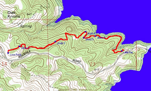
Lone Rock to Little Flat Hike.
The trail from Lone Rock to Little Flat is very scenic. You will pass through second-growth Redwood stands, small stands of Madrone, open grassland and Chaparral. The trail is 2.1 miles long and has gentle slopes. This trail does not loop so it's best to treat it as a point-to-point trail, leaving one car at the bottom and one at the top of the trail. Your other option is to combine this with another trail or hike back up Rockpile Road. If you are planning on hiking this trail in the summer, bring plenty of drinking water.
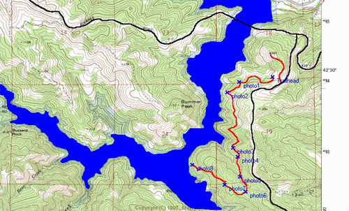
Southlake to Quicksilver Hike.
This is probably one of the easiest trails to hike in the park. It has very gentle slopes and the view from the trail is spectacular. The hike is about 5 miles long round trip and will take about 2 hours to walk. The trail does not loop so you will be walking back the same way you came. The best time to walk this trail is in the morning or late afternoon. If you hike this trail in the summertime, make sure you bring water and possibly a bathing suit for a brief swim at the Quicksilver Campground. There is a wide variety of wildlife that can be seen along this trail. Several rangers have run into wild boar, deer, California Quail, Western Fence Lizards and Turkey Vultures.
Download Lake Sonoma's Trail Map:
Lake Sonoma's Trail Map (PDF)
Rockpile Road area Trails (PDF)
These hiking maps are copyrighted by ULTRARUNNING Magazine, 2009 and used by permission