PETALUMA RIVER
CONSTRUCTION
PROJECT LOCATION AND DESCRIPTION
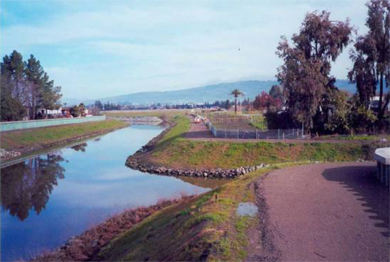
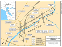
The Petaluma River flows southward through the City of Petaluma, which is approximately 35 miles NNW of San Francisco, California, and drains into San Pablo Bay. The Locally Preferred Plan (LPP) includes improvements to a 3,500-foot section of the Petaluma River that flows through residential and commercial developments near Lakeville Avenue and the confluence with Lynch Creek. The project will provide the following levels of protection: (1) Federal Emergency Management Agency (FEMA) 100-year flood to year 2005 under general plan build-out; and (2) FEMA 40-year flood by the year 2040, assuming residential and commercial development of the watershed continues at the current pace.
|
TOTAL FUNDING
|
|
|
TOTAL COST
|
$ 46,140,000
|
|
FEDERAL COST
|
$ 31,991,000
|
|
NON-FEDERAL COST
|
$ 17,149,000
|
|
|
|
|
TOTAL FEDERAL COST THROUGH FY 2020
|
$ 29,176,296
|
|
FY 2021 BUDGET
|
$ 0
|
|
COST TO COMPLETE
|
$ 2,814,704 |
FY 20 ACCOMPLISHMENTS
- Completion of the Operations and Maintenance (O&M) Manual.
- Project turnover to the Non-Federal Sponsor (NFS)
FY 21 ACCOMPLISHMENTS
- Fiscal Closeout of the project
ISSUES AND OTHER INFORMATION
- The City of Petaluma is the NFS.
- The Water Resources Development Act (WRDA) of 2007 provided for a project cost increase associated with an embankment failure and the need to conduct additional floodwall failure studies.
- The project is substantially complete with no more expected physical work.
CONGRESSIONAL INTEREST
- 2nd District, Rep. Jared Huffman
POINT OF CONTACT
- Deputy for Project Management, Edwin S. Townsley, (415) 503-6593.
Updated on 18 February 2020

Click Map to Zoom In