Waters of the United States - 2023 Conforming Rule

On September 8, 2023, the U.S. Environmental Protection Agency (EPA) and the U.S. Department of the Army (the agencies) announced a final rule amending the 2023 definition of “waters of the United States” to conform with the recent Supreme Court decision in Sackett v. EPA. The agencies are committed to following the law and implementing the Clean Water Act to deliver the essential protections that safeguard the nation’s waters from pollution and degradation. This action provides the clarity that is needed to advance these goals, while moving forward with infrastructure projects, economic opportunities, and agricultural activities.

Geographic Jurisdiction Overview

Aquatic Resources Delineation and Jurisdictional Determination


Submit your Aquatic Resource Delineation Report via: https://rrs.usace.army.mil/


The Corps of Engineers receives thousands of requests each year to perform aquatic resources delineations for potential applicants for permits under Section 404 of the Clean Water Act. Due to limited staff and resources, response time can be several months or longer. To expedite this process, the District encourages applicants to use consultants to conduct preliminary wetland delineations, especially for large and/or complex areas.

Delineations Reports submitted to the District for review and verification need to meet the following standards:

USACE Jurisdictional Determinations and Permit Decisions Viewer

Aquatic Resource Upload Sheet

A completed copy of the Aquatic Resources Excel spreadsheet -located in the ZIP archive below- is requested when submitting large and/or complex Aquatic Resources Delineation Reports. This spreadsheet facilitates efficient and accurate data entry into the Corps’ database.

 Data Validation

The spreadsheet contains validation tools to ensure accuracy of the data prior to submittal. Performing the validation upfront will alleviate the need for back-and-forth correspondence between the requester and the Corps to correct any possible errors in the data. To run the validation tool:

  1. Enter all data in the appropriate columns and tabs.
  2. Ensure that that for each aquatic resource, the amount field contains a value greater than zero.
  3. If data is copied into the worksheet using the Paste Tool, ensure that you paste only the values, as other paste methods can alter the format and cause the validation to fail.
  4. Once you have completed entering the data and have saved the document as a XLSM file, click the gold shield at the top of the workbook window.
  5. The tool has a tool-tip showing "Validate Worksheets."  After clicking this button, data validation is performed and potential errors are added to the Validation tab.
  6. The Validation tab is opened after the process is complete to allow the user to see the output.
  7. The validation output includes the tab (data type), column, and cell for where the possible error was found and a brief explanation of the issue.
  8. The majority of the validation checks are captured in the Rules tab of the workbook.

If you encounter any issues in using the validation tool or the new workbook, or if you have any questions, please contact cespn-rg-info@usace.army.mil.

Updated 31 January 2024

Delineation Resources

Collapse All Expand All
 National Manuals
 Regional Supplements
 Automated Wetland Determination Data Forms
 National Wetland Plant List

National Wetland Plant List (NWPL)

  • The NWPL provides the most recent list of wetland plants by species and their wetland ratings and should be referenced on data forms used in the wetland delineation. (update May 18, 2020)
  • Changes from the 2016 list can be found here.
 Navigable Waterways

U.S. Coast Guard List of Navigable Waterways with the San Francisco District (2 August 1971)

Regulatory Jurisdiction

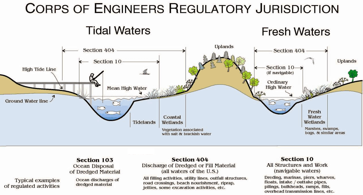
The U.S. Army Corps of Engineers has permitting authority over activities affecting waters of the United States. Waters of the United States include surface waters such as navigable waters and their tributaries, all interstate waters and their tributaries, natural lakes, all wetlands adjacent to other waters, and all impoundments of these waters.

Two federal statutes mandate Corps jurisdiction over navigable waterways and adjacent wetlands. These are Section 10 of the Rivers and Harbors Act of 1899 and Section 404 of the Clean Water Act.

Collapse All Expand All
 Limits of Jurisdiction

  • Territorial Seas. The limit of jurisdiction in the territorial seas is measured from the baseline in a seaward direction a distance of three nautical miles. (33 CFR 329.12)
  • Tidal (Navigable) Waters of the U.S. (PDF) The landward limits of jurisdiction in tidal waters:
  • Non-Tidal Waters of the United States. The limits of jurisdiction in non-tidal waters:
    • In the absence of adjacent wetlands, the jurisdiction extends to the ordinary high water mark, or
    • When adjacent wetlands are present, the jurisdiction extends beyond the ordinary high water mark to the limit of the adjacent wetlands.
    • When the water of the United States consists only of wetlands the jurisdiction extends to the limit of the wetland.
 Corps Regulations / Statutory Authorities
The regulatory authorities and responsibilities of the Corps of Engineers are based on the following laws:

Other laws may also affect the processing and evaluation of applications for Corps of Engineers permits. Among these laws are the National Environmental Policy Act, the Coastal Zone Management Act, the Fish and Wildlife Coordination Act, the Endangered Species Act, the National Historic Preservation Act, the Federal Power Act, the Marine Mammal Protection Act, and the Wild and Scenic Rivers Act.

Administrative Appeals

The Corps of Engineers has an administrative appeal process whereby applicants and landowners may appeal denied permits, issued permits that contain requirements that are unacceptable to the applicant, or jurisdictional determinations. 

Reference Links

Regulatory Links

Redirecting...